Circle the Cirque Crest
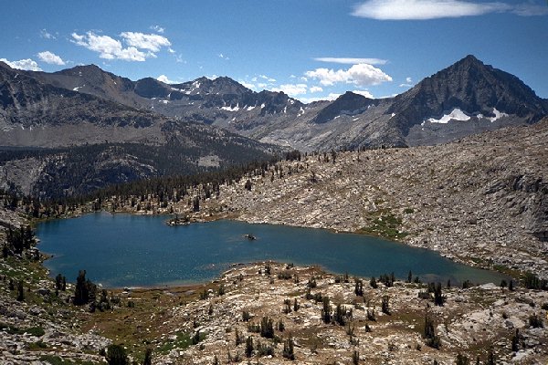
The lowest lake in Cartridge Basin with its charming little island which looks like a small sailing ship. Arrow Peak dominates the skyline, with a small peek at Bench Lake on the far left. The trail meets the lake below about mid-lake, then travels along the shore to the left and fades at the outlet.
Beyond Cartridge Pass
Circle The Cirque Crest - By D.W.Donehoo (All rights reserved)
Where is a kite when you need one? The pass was so windy that when I took a picture I had to lean far into the wind to stand. The views however were exceptional on both sides of the pass. We dropped our packs and sat out to have lunch part 2 on the south side of the pass, well out of the wind, and admired the panorama below. Arrow Peak dominates the south horizon, and Bench Lake really lives up to its name. The Muro Blanco sweeps out of sight below, giving no hint of the thrills and chills it has in store for us. Peaks are everywhere, near and as far as the eye can see, and on that day that was pretty far. The landscape and peaks around us were pure classic Sierra high alpine granite, the sky a cobalt blue you can only get by being in high places. Out of the wind it was warm and sunny, causing us to reach for the sun block and sun glasses. After our visual and culinary feast, we stepped off on the trail. You won't find this trail on any of the newer maps because it is not maintained, but the next section was as about as good as any average trail in the wilderness. In most places it looked as if it had been maintained every year, and from the deer tracks, it was still getting a lot of use. From the top of the pass to the Muro Blanco below there were only two or three sections where the trail faded or was confusing, and in many spots it looked as if the trail was constructed only recently. There were only one or two blow-downs or deadfalls lower down on the trail, all easily bypassed.
From the pass, the trail winds its way downward on an easy grade. In a couple of grassy, granite, or dirt spots the trail fades as trails often do, but the going was remarkably easy.
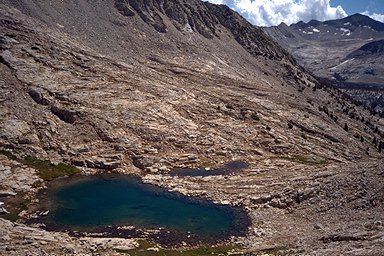
Soon we found ourselves above the first large lake, and here the trail becomes interesting. The slope the trail descends is very steep, and the trail was a long grove traverse cut out of the side of the slope. In one spot the trail was a bit eroded and you had to watch your step, but it was not a serious hazard to cautious backpackers such as ourselves. Finally at the outlet of the large upper lake, the trail fades away, and here we lost the trail. I will call this lake "Upper Cartridge Basin Lake ". We traveled on a short way and came to a cliff, obviously not the right way to go. So we did what mountaineers often do in an indecisive situation. We sat down and finished our lunches.