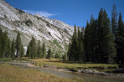
Circle the Cirque Crest

Looks nice, doesn't it? This was one of the more ideal spots in the Blanco. Here we are looking back towards where we would of rather have been, the Cartridge Pass lake basin. We had just crossed over the not-so-mighty-here Kings River off to the right. We should of stayed on the other bank longer.
The Muro Blanco, Day 1
Circle The Cirque Crest - By D.W.Donehoo (All rights reserved)
WARNING! I do not recommend the following section for a hike of any sort. The Muro Blanco is choked with bush and talus from end to end, there are the dangers of often high and swift water, it is populated by rattlesnakes and possibly overly inquisitive bears due to the proximity of a large population of problem bears, and there may even be a chance of alien abduction. Who knows. This is NOT a challenge, but a warning of the great grueling difficulty that travel presents in the Blanco. Travel is VERY hard and sometimes risky work. It should be attempted only by very experienced backpackers with experience in cross-country travel in difficult terrain, especially talus. If you insist on going, wear clothes resistant to tearing that will protect your arms and legs. Carry as little weight as you can get away with. Give yourself plenty of time (three or more days), take your time, and quit early: hard cross-country should not be attempted by tired people. Follow these suggestions, and the grueling work may be balanced by the grandeur of the Muro Blanco. Maybe.
Day 10. Monday, September 8. Every morning seemed an improvement over the last, with nary a breath of wind to stir the perfect reflection of Arrow Peak on the waters of Bench Lake, and the sky an unblemished blue you can only get at higher altitudes. We made haste to break camp, and as it turned out, we needed every minute of that day to get as far down the canyon as we could. We cruised down the lake shore, passing some backpackers who thought we just arrived at the lake, because after all the direction we were going the trail ends at the end of the lake. After the trail ended, we began traversing around to the left on the route we scouted the day before. At first the going was very good as we skirted a small pond and meadow and began moving into the valley west of Bench Lake. However, the valley began to reveal its true nature as we began to descend. At one time in the distant past the whole valley was solid talus and moraine, but as time passed, trees began to claim the area and fill in the talus with soil. Today the walking is somewhat steep but manageable, with trees and deadfall providing some obstacles to downward progress. In addition, we could see large open areas of solid talus which tended to herd us to the right to steeper terrain, which we were trying to avoid. As we dropped lower, the cliff area to the right and the talus to the left funneled us into a steep area. We wanted to head for the shallow angled area down to the left, and we saw that the large open area of talus to our left had finally given up to the trees, presenting us with a narrow traverse to the left on a good game trail, which we happily followed. It seemed to us we had found the only choke point leading downward allowing safe travel. Hopefully others who follow will find the same route. Thereafter the travel became progressively easier under canopied sparse forest carpeted with pine needles, until it abruptly leveled out near the river. We turned left and began crossing a large forested delta area with many streams until we hit the South Fork Kings River and a decision. Across the river was open sunny meadow, and on our side was some bush, and harder going....we thought. So we changed to shoes and waded across, changed back to boots, and had a snack and rest break. We were in need of a break after the steep descent, but what we didn't know was the day and the hard work had barely begun.