Deadman Canyon Loop
Silliman pass is that wooded area on the lowpoint on the horizon. This is one of the Twin lakes
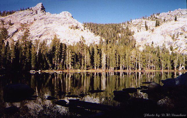
Twin Lakes
Deadman Canyon Loop - By D.W.Donehoo (All rights reserved)
Getting to the trailhead: From the North, go down HWY 99 to the Jenson exit. Take the Jenson road East until it dead ends at Academy. Take a left and go 2 miles to Kings Canyon Road. Turn East (right) and follow the signs to Kings Canyon entrance. When you get to the Generals Highway, take it south (right) to Lodgepole. Coming from the South, go up HWY 99 to the HWY 198 exit. Go east, staying on HWY 198, following the signs to the entrance of Sequoia NP. Take the incredibly winding road to Giant Forest, and then on to Lodgepole. (If you think THAT road was crazy, visit Mineral King for real road insanity.) Once you turn onto the Lodgepole entrance road, continue on down the road to find the huge trailhead parking lot to the right of the road (and actually just a big widening of the road) less than a quarter mile past the campground entrance booth. You may be given a tag or something at the booth if you explain you are there for long term parking for an extended backpack, but their methods change from year to year. After parking and securing your vehicle (from bears mostly), continue down the road and cross the bridge and look for the trailhead sign to the right. Finding the actual trail can be confusing until you realize that as you face the trailhead sign, the trail heads off directly to the left, skirting the campgrounds that are further to your left. Getting a permit: When you turn off the Generals Highway into Lodegepole, to your left you will see a gas station followed by a group of buildings. These buildings house the Ranger Station with book store and museum, Wilderness Permit office, some showers (!) and bathrooms, a small restaurant, a souvenir shop and a general grocery store with a little bit of everything for campers, backpackers and anyone else who can not go without the modern conveniences. The store does carry stove fuel and dehydrated food, gorp and other useful items in case you need to stock up for some reason. These facilities are open year round. The wilderness permit office is in the same building as the museum, which is behind the restaurant. There are summertime trailhead quotas for all trailheads in the area and permits are requires for all overnight (or multi-day) backcountry travel. While most camps you will be staying at have bear boxes, those in Deadmans Canyon do not (at least when I was there last), so proper food hanging technique is a must. However, count yourself privileged to see any bears at all in the more remote areas. (Actually, Crescent Meadows is the most likely place to see bears going about their natural business.) See "The Best Way To Bearbag Your Food".
The Deadman's Canyon Loop Trip, starting at 6800 feet at Lodgepole: After skirting several car campsites as you travel north, the trail swings west and uphill on a gentle to moderate grade for less than a mile before leveling off and heading north through a thick forest. You may be able to spot some small meadowed areas through the trees on this relatively level respite of 1 mile. The trail then begins to climb moderately and eventually curve to the left (west) to meet Silliman Creek, the first potentially difficult crossing if you have started early season. If you cannot do a step-over or wet ford, you may be able to find a log upstream, or possibly a better crossing point. Campsites used to be in this area before Rangers removed the fire rings and obliterated the camp spots, all for the good.
The trail continues to climb moderately and winds north to Cahoon Meadow, and the first legal and established camp sites. There are no bear boxes here and water must be fetched
from the meadow outlet stream, which may be at a trickle late season: check first before unpacking. This is a good place to rest before the next pull up the trail, having traveled about 2 miles.
Looking out over the meadow, you can see the skyline dip down at Cahoon Gap, your next destination and this site line would be the hypotenuse of a large triangle that the trail makes the other two sides of. All this is to say the trail is not the shortest distance between two points, which means you have some walking to do to get to the Gap. The trail begins a fairly moderate tedious climb that is mostly shaded for the first half of the climb to the gap and then is hot and exposed for the last half until you finally get to the broad shady saddle that is Cahoon Gap, at 8650 feet. You should start to feel you are finally getting away from civilization as you gratefully descend, sometimes steeply, to a tributary of the East Fork Clover Creek and some level walking. When you get to the creek, stay alert because the trail will appear to end abruptly near the creek and you have to find the proper crossing point to the trail which takes off at a right angle from the creek. When you cross the creek, look to your right to see the many camp sites on the gentle hillside. There is a bearbox in the this area. Going further down the trail you will come to a junction to the trail to J.O. Pass. We stay on the main trail to the right fork and soon come to another bear box and more camp sites. Take off your pack and rest awhile here, because you have some real climbing ahead and now you are at an altitude (8434 feet) that will begin to test your lungs and legs. The scenery is beginning to say you are approaching the alpine zone and if you are like me you are excited to be at the threshold of the high country so near the backbone of the Sierra. At Lodgepole, you were at the edge of glacier country, but now you are in the high country and will soon be in the thick of it. If you do not have the time or energy to go on, stay here for the night and push on to Ranger Lake or Twin Lakes in the morning, Most backpackers will want to at least get as far as Twin Lakes on the first day. So far, you have gone 5.7 miles.
Re-shoulder your pack and get the fit just right because its time get down to work. The trail resumes its level course for awhile, then abruptly ramps up moderately, sometimes steeply on what is mostly an unrelenting climb. The work is offset by the rapidly changing scenery with occasionally modest views, but what will really make your climb is a broad granite staircase waterfall\cascade (in early season) that says you are approaching the granite heart of high Sierra! Near the falls and a few steps up the trail is your first expanse of flower planted glacially polished granite pavement of the trip and it won't be your last: it's just a taste of what is to come. Leaving the granite area, you enter another big tree forest canopied section and a short respite in your sometimes steep climb. Soon the trail resumes its rugged upward course and you just have to settle in to the rhythm of what is becoming a fairly strenuous climb. This is to be expected on your first day on the trail with your heaviest pack and your unaclimated lungs on what may very well be a sweltering day. As you near your goal, the trail just seems to get steeper, but at last you thankfully arrive at Twin Lakes (at 9430 feet and about 8 miles), which features numerous camp sites, bear boxes, two beautiful lakes and a toilet that gives a new meaning to the words "outdoor toilet". Twin Lakes is a worthy first day goal, but the really hardy souls in excellent physical shape may want to continue on to Silliman Pass and Ranger and Beville lakes.