Deadman Canyon Loop
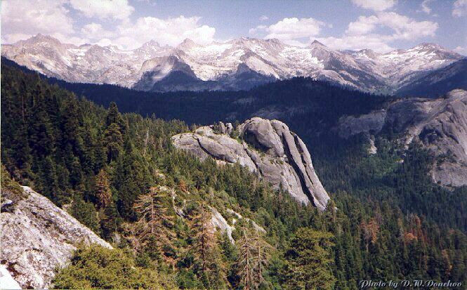
The Great Western Divide panorama stretches out over Sugarbowl Dome.
The High Sierra Trail
Deadman Canyon Loop - By D.W.Donehoo (All rights reserved)
Like many named places in the Sierra, Bearpaw Meadows also has an interesting story about its name. As anyone who has spent any time in the Sierra knows, bears frequent meadows and other wet growing areas to graze and Bearpaw Meadows is no exception. I have seen two bears feeding in lower Bearpaw Meadow, and Rangers will tell you these meadows are prime bear watching areas. It was sometime in the dusty past when someone decided to rid himself of a bear and set a beartrap attached to a log in the meadow. The bear was caught in the trap, dragged the log across the meadow until the log was hung up in some rocks. The bear went over a small cliff and left behind its paw in the trap. There seems to be alot of unhappy tales in the Sierra.
The next section, 11 miles to Crescent Meadow, is the fastest and easiest section of the hike. The trail is a broad backpacker freeway in places and very busy all season long. While there are many level or nearly so sections, the trail is characterized by very few switchbacks, snaking in and out of water cut canyons and climbing and descending seemingly innumerable times; a real Sierra rollercoaster. Nearly all of the climbs are easy, a few are moderate and only the climb out of Buck Creek Canyon is anywhere near strenuous. Your altitude will fluctuate between 7600+ feet to about 6800 feet and while you will end up about 800 feet lower than when you started, you will climb a total of 3214 feet and descend 4746 feet! Nonetheless, you will be able to make outstanding time,
falling into an almost unbroken rhythm, stopping only for short rests, water breaks and maybe lunch or snacks. Early season, there are many places to filter water, but don't wait until you are completely out before refilling your water bottles. No matter how late the season, you should be able to find water in most of the deep stream cut canyons, but there
may be long walks between watering spots. On one hike I left Hamilton Lake at 7:30 AM and arrived at Crescent Meadow before 2 PM, a hike of about 15.6 miles, but I had been on the trail for two weeks prior to that. Your mileage may vary.
All of the High Sierra Trail is impressive fun and the Bearpaw to Crescent Meadow section is fairly laid back as trails go. If you HAVE to go home, this section is a mellow good-bye. Starting in the park-like big tree environs of the Bearpaw Ranger Station the trail ascends to the shoulder of the Sugarbowl Dome ridge and descends into a pleasant small shaded wooded valley. After a few rare switchbacks, the trail descends to Buck Creek. The crossing here had a bridge a couple of times in the past, but all were washed or torn away by avalanches. Now there is a low concrete bridge that may be awash very early season, therefore making it a dangerous crossing. If this is the case (and you would likely find out at the Bearpaw RS ), you may be forced to descend to lower or Little Bearpaw Meadow to take the trail to Buckeye Flat, where Buck Creek is crossed on a good bridge. Most likely, it will be safe to cross. Find out conditions before you leave on your trip.
Climb steeply out of Buck Creek Canyon, a hot and exposed grunt on a warm clear day. Eventually the trail grudgingly levels out and offers the hiker some welcome shade. As you round the ridge, you may want to drop your pack for a short rest. While you are there you can look for the last traces of an unmaintained trail that went straight up the ridge to Moose Lake. You may also see the first views of Sugarbowl Dome. Continuing up the trail you reach the last high point of the hike at about 7600 feet and see what is typical of this hike on the HST: rounding a ridge to travel to the stream or streams that cut into this part of the mountainside, followed by another hike around a ridge, over and over again. The next ridge shoulder brings the hiker close to Little Blue Dome, and some use trails to visit the dome. Over the next few miles of in and out, up and down hiking, keep your eyes open for gratifying views of Little Blue Dome, Sugarbowl Dome, Moro Rock, Castle Rocks, and the Great Western Divide. At 5.6 miles from Bearpaw Meadow you will possibly see the little used Mehrten Meadow trail. Those hikers (with a lot of strength or an extra day) heading directly back to Lodgepole can take this trail to Panther Gap, Wolverton Creek Creek trail, Wolverton, and on to Lodgepole ending at the backpacker parking lot. There is camping at Panther Gap.
Forging ahead, you round Seven Mile Hill for more views through the trees of the Great Western Divide before entering the vast bowl of Panther Creek. At 9.7 miles from Bearpaw Meadow you will see another little used trail to the Congress Group of big trees and Wolverton. Just before you reach this junction you will pass the last little seasonal stream and if you are low on water, you should get some here or one of the streams along the last two miles before the trail junction. At the junction, you only have 2.4 miles to go to the next junction, but it is no fun to hike thirsty in the hottest part of the day, so keep an eye on your water supply.
You will know you are nearing the end of your journey when you pass through a burned area (from the 1988 Buckeye Flat fire, fought by 1200 firefighters costing millions of dollars) and reach Eagle View. Take your last view of the Great Western Divide and all of the points of interest previously mentioned in the Middle Fork of the Kaweah River basin if
the afternoon smog allows it. Tread the last expanse of exposed flowery rocky trail to enter the extensively meadowed region of Giant Forest and a trail junction. Follow the signs to Crescent Meadow past Log Meadow and Crescent Meadow where you will probably have your best chance to see a bear all trip.
Sadly, your journey is done and you finish it a stronger and better person for it. In the summer you can take the shuttle to Lodgepole for the last leg of your trek, finishing with a short hike to your vehicle at the parking lot. Happy trails.
REFERENCES:
Sierra South: 100 back-country trips in California's Sierra/Thomas Winnett...[et.al.], 6th Edition.
A treasury of the Sierra Nevada/Edited by Robert Leonard Reid.
Name Places of the Sierra/ Peter Browning.