Circle the Cirque Crest

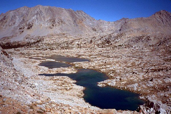
The highest lakes of Lake Basin, just below Cartridge Pass. There is a faint trail that turns these lakes on the right.
The Lakes of Lake Basin
Circle The Cirque Crest - By D.W.Donehoo (All rights reserved)
We headed south to what I call "L Lake", because it is shaped like a giant "L". On the way we discovered traces of the old JMT, and just beyond, "L Lake".
Lake 10,632, or "L-Lake" as I call it.
Here camping is more practical if still a bit exposed. However, the beautiful alpine lake and surroundings making it a worthwhile camping area (but why would you camp there if you had Marion Lake or the lake just above it to choose from?). From the lake you can see there is another "step" in the basin to climb, so we went back to the JMT and began to follow it. Sure enough, as it neared the cliffs the trail became very defined (maintained by deer no doubt) and switchbacked up the steep section to the next level expanse of basin and faded again, but not often disappearing for any great length, always being just visible or somewhat easy to find ahead. Route finding became trail finding. While the cross-country is easy and the trail is not needed most of the time, it is easier to use the trail (which does seem to be extensively used by deer and other critters) to bypass bushy areas, cliffs, and other obstacles. Also, by staying with the trail, it cuts down on the impact to the rest of the area. In many areas in the basin, the trail is there to stay. Deer and humans are a part of the world and wilderness, and it is only right our trails should be a part of it. Humans were never the first trailmakers, and humans should tread as lightly as deer. The trail, sometimes well used, sometimes faint, works its way to the highest lake, which I call "Cartridge Pass Lake", over open slab granite studded landscape. The lake is turned to the left (north) side, and as you get closer to the pass, the trail becomes well defined. As we rounded Cartridge Pass Lake, the pass comes into view and we wondered just how to get to the top of that talus heap? To the left to gain the top of the cliffs, or up the talus slope?
Lower Cartridge Pass. As can be seen, the Cartridge Pass trail, the old JMT, is still there and usable.
As we reached the main inlet of Cartridge Pass Lake, all questions were answered. Here the trail became very pronounced and it marched right up to the talus slope and began switchbacking upwards. We hiked up a ways and found the trail to be very steep and primitive, obscured in one ducked section, but very usable. Once again we found hundreds of deer footprints on the trail and only one set of human ones. (Obviously deer trail maintenance at work.) Did I mention we found little evidence of human activity in the basin? At the base of the pass there was an old rusty horseshoe sitting on a large rock, we saw one set of fairly recent human footprints, no other people, and not much else. We headed
back after admiring Cartridge Pass Lake from above on the pass trail. We decide tomorrow we would take this trail out of the basin. On the way from the pass we tried to set up a few ducks to make better use of the trail and stay off meadows and flowers when we came back this way the next day. Duck foes may have a fit, but some ducks can be useful for preservation, when used wisely..