A Walk on the Tablelands
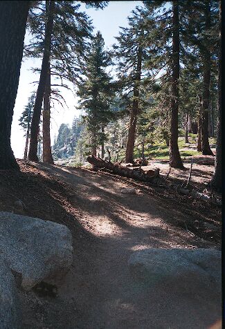
The last 100 yards are a grunt, but the view is the reward for the effort here at Panther Gap.
Panther GapA Walk on the Tablelands - By D.W.Donehoo (All rights reserved)
Tablelands, June 25 to 28th.
The Tablelands are located above Lodgepole in Sequoia National Park, and is known for its vast expanses of clean white granite. I had longed to go there and explore its secrets, and that June I finally had my chance.
Around 6PM Thursday, June 24th, we hit the road for SEKI, free at last, fleeing to the freedom of the mountains! We drove in to our primitive camp off the Big Meadows road near 10PM, a spot where I could pull in the 4x4 near a very level spot. I used the tent (sans rainfly) and Dave opted to use his bivy. The night was only cool, and the night sky was lit up by the moon nearing full. Once bedded down, it was almost too warm for a sleeping bag, but that did not keep us from sleeping very well. The 7500 foot altitude also helped us get acclimated, for we would need all we could get in the coming days...
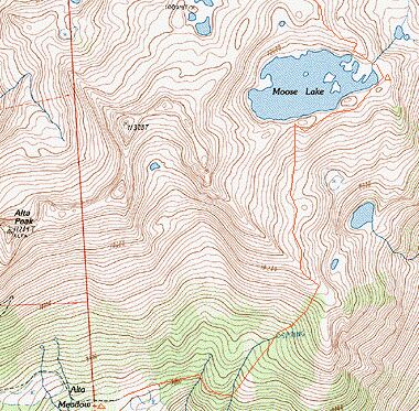
This was our general route to Moose Lake and beyond to the Tablelands. An old 15 minute map would have a more exact track of the unmaintained trail from Alta Meadow.
FRIDAY, June 25:
The next morning, we arose early and headed for the Lodgepole Ranger Station. After a humorous exchange with the Ranger and enduring yet another lecture on zero impact camping, we had our permit in hand and shortly afterwards, a breakfast in stomach. At the Wolverton TH parking lot, there seemed to be plenty of people on the trail judging by the
number of cars in the lot, but we were destined to see few people on our hike. We wasted little time getting on the trail to Alta Meadows, the first stop on the way to the Tablelands. The day was already hot, and the steep trail and altitude made itself known almost immediately, combining to making me dissolve into a sweaty panting wretch. I KNEW I was in good physical shape, but nothing prepares you for hiking at altitude except hiking at altitude. The trail climbs steadily upward on the crest of the classic lateral Lodgepole glacial moraine, and the trail is very steep in places. In one section the trail, it climbs sharply upward in shade without letup for about 100 yards. Shortly afterwards, the trail meets a junction, and we turned right towards Panther Gap.
The travel turned easier on this leg of the journey until we neared Panther Gap itself, where the trail broadly switchbacked upward to meet Panther Gap and its wide views. Here we stopped for our first snack and rest break, and enjoyed our view of the Great Western Divide, the Marble Fork of the Kawea River, and the Valley.