Kern-Kaweah and Kaweah Basins
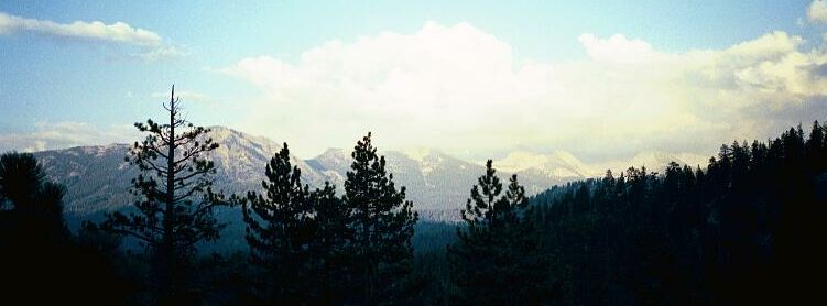
Sunset in the Sugarloaf Valley, looking towards the Great Western Divide and Mt. Brewer.
Sugarloaf Valley
Kern-Kaweah and Kaweah Basins via Colby Pass, September, 2000.
In the camp I dropped my pack and after we looked the place over, we discussed things and decided it had been a long tiring day and it was getting late due to our late start. We decided to stay, despite the rather run-down beat out look of the general area. There were no true level spots, and the one nearly level spot was a small one, so we decided to share that spot. For the only time that trip I slept out on my groundsheet for a nose chilling experience. The day had been a hot sweaty one, but that night was rather cool.
After dinner and chores, we stashed our food in the handy bear-box, and hiked the general area to obtain some views. The sun was rapidly setting and we were rewarded with some fine views of the north end of the Great Western Divide from the shoulder of the Sugarloaf. We looped back to camp by hiking down to the meadow (where I stepped into a deep sucker-hole that soaked my foot) where we enjoyed a fine view of the Sugarloaf dome over the meadow. I have written about this rock formation before, but suffice to say it is the goal of some rock climbers for the pitches they find there. The Sugarloaf is the dominant feature of the valley, and I have seen it from as far away as the summit of Mt. Brewer. It is a finely tapered granite dome atop a granite ridge, and I am sure its summit would offer fine views of the valley and surrounding peaks. To me, the dome looks like a huge bullet-shaped monolith.
Back in camp it was time for the evening chores and a relaxing evening of reading and stargazing. Finally, the cold chased me into my bed and a good night.


